Tour de Valli: Stage 4 - To Valley City

This stage turned out to be the longest and hotest. Due to not being a direct paved route from Mapleton to Valley City, I needed to head north to get on a western route. It did not prove to be easy as you will see.
Got up early. About 7ish. No problems in Mapleton. I suppose the train traffic could be thought as being a problem as it was about 300 yards from my tent. However I have found that to be a sound of security. Still, train traffic was plenty high the course of the night.
I found the actual city park on the other side of town. It was tucked in the middle of a residential development.
Soon, I met up with the first sign of route problems. The road heading north out of town was closed for construction. And it was impassable. I searched for another road north to no avail. Reluctantly, I headed south to the Interstate in hopes of finding a westbound road. Providentially, there was a paved frontage road on the south side of the Interstate which I took all the way to Casselton. I stopped and ate a bit before moving on but not before staring at the glory of the Largest Can Pile in the World.
Took State Route 18 North to 25th St SE in order to go west on pavement. Stopped for nourishment outside of Ayr, then hopped on State Route 38 going south. Took a break in Buffalo to nap and get out of the midday sun.
Followed 34th St SE to Tower City and stopped at an unusual and lonely historic marker. It marked the spot where General Sibley returned after driving a bunch of Native Americans across the Missouri River during a stage of the Dakota Conflict of 1862. Later on the tour I would overnight in Sibley, ND named after him. Hastings, MN, my hometown, is another Sibley namesake.
 According to one of my maps, I could take a 33rd St SE for about a mile on gravel then the rest of the road would be pavement. Totally false. The road was also recently re-graveled and difficult to ride on. I had to ride the harder sections on the shoulders. After Oriska the road got better but then totally disappeared at an intersection with a road that looked like a cow path. I followed this "road" north until it reached a larger gravel road, apparently 32nd St SE. At State Route 25 I headed south and picked up 33rd St again. The rest was downhill on the gravel into the north side of Valley City. They don't call it Valley City for nothing. It was quite a change in topography compared to the flat rolling land I saw most of the day.
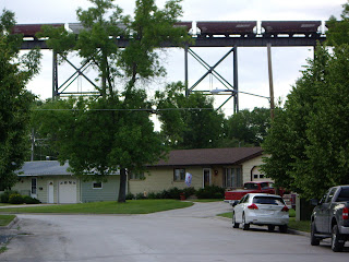
The first thing in town I noted was High-Line railroad bridge. This bridge was built to carry the Great Northern over the valley. It dominates the skyline on the north side. Numerous other bridges dot the town which I later would visit. But first I needed a place to stay. I found a spot to camp at the tourist campground. It was cheap, not very scenic but in town and had a shower. I was the only tent amongst a glut of motor homes. I pitched my tent on the old railroad grade (because that was the tenting area.)


Comments